

1
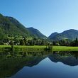
A trail connecting the villages of Taninges and Mieussy along both banks of the Giffre River. A long and varied route through forests, villages, and rivers!
Choose gear that's appropriate for your skill level and the weather. Stay on the marked trails.
Comforts
Services
- Pets welcome
Furniture
- Picnic area
- Public WC
- Car park
Itinerary
- Distance: 19.6 km
- Duration: 5h35
- Type of land: Ground, Not suitable for strollers
- Markup: Quite challenging due to its length: 19.3 km, but the route presents no particular difficulties, consisting mainly of gravel paths and a few sections of paved road (some sections may be wet in the spring or after thunderstorms).
- Maximum altitude: 858 m
- Elevation: 510 m
- Vertical drop: 510 m
- Positive elevation: 510 m
Services provided
Visits
- Group visit duration: 335 min
Prices
Free access.
Opening
All year round daily.
Subject to favorable snow and weather conditions.
Subject to favorable weather
This service provider also proposes
Taninges