This tour, starting from the village of Sixt, crosses the vast plain of La Glière by a small road leading to Hauterive. From this plain, there is a remarkable view of the Tenneverge and, on the opposite side, of the impressive pillar formed by the Pointe de Sales.
Comforts
Services
- Repair kit
Furniture
- Car park
- Free car park
- Public WC
Itinerary
- Distance: 6 km
- Duration: 60 min
- Elevation: 110 m
- Vertical drop: 110 m
- Positive elevation: 110 m
Prices
Free of charge.
This service provider also proposes
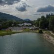
The Lac Bleu outdoor activities area
Morillon
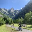
Mountain biking route – Fer-à-Cheval >...
Sixt-Fer-à-Cheval

Complementary services
Guidebook with maps/step-by-step